


In our ongoing commitment to sustainable farming practices, we are one of the industry leaders in low input farming with the goal of having a minimal impact on the environment while producing the highest quality fruit. To be a good steward of the land, winegrowers must be environmentally and socially responsible. Towards these ends, we have improved water conservation and forgone herbicide use, and we practice fair-wage compensation. We are a LIVE certified sustainable and salmon safe vineyard, that utilizes integrated pest management, moisture monitors,
cover crops and mycorrhiza applications to enhance microbial soil diversity. To bolster beneficials, we plant insectaries and promote native vegetation. The soil at Les Collines Vineyard consists of mostly Walla Walla Silt Loam, with some Athena Silt Loam resting on top of ancient gravel. Originating from deep windblown silt loess deposited by ancient glaciers, it is nutrient rich with excellent drainage, ideal properties for vineyard cultivation. Our gentle approach to farming makes us a friendly neighbor to the Riparian Area Restoration Project on our border.

Pictured above: Brad Sorensen, Vineyard Manager/Viticulturist
Our Mission
To be a responsible producer of premium wine grapes in the Walla Walla Valley.


Terroir
↓

A Study By Dr. Kevin Pogue
Dr. Kevin Pogue is a professor of geology at Whitman College in Walla Walla, Washington. For 25 years he has conducted extensive research in the Pacific Northwest on the geological influences on terroir, a topic for which he has been recognized as a “leading global expert.” In 2018 the Washington State Wine Commission awarded him the Walter Clore Honorarium for his service as an “ambassador, mentor, and champion of Washington Wines.”

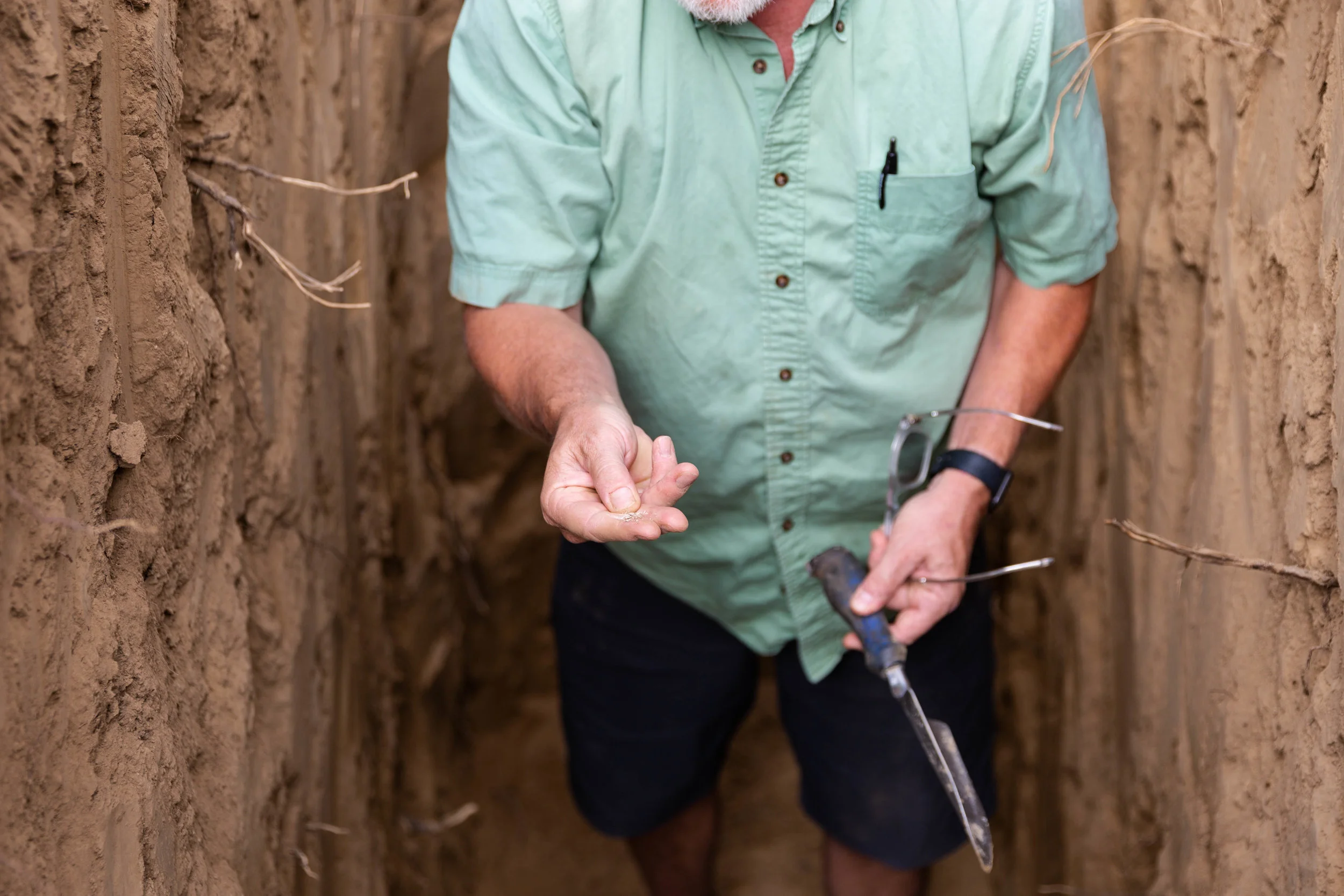
Pictured above: Dr. Kevin Pogue in a fallow 1 acre at Les Collines to be planted to Grenache in ‘19
Geography
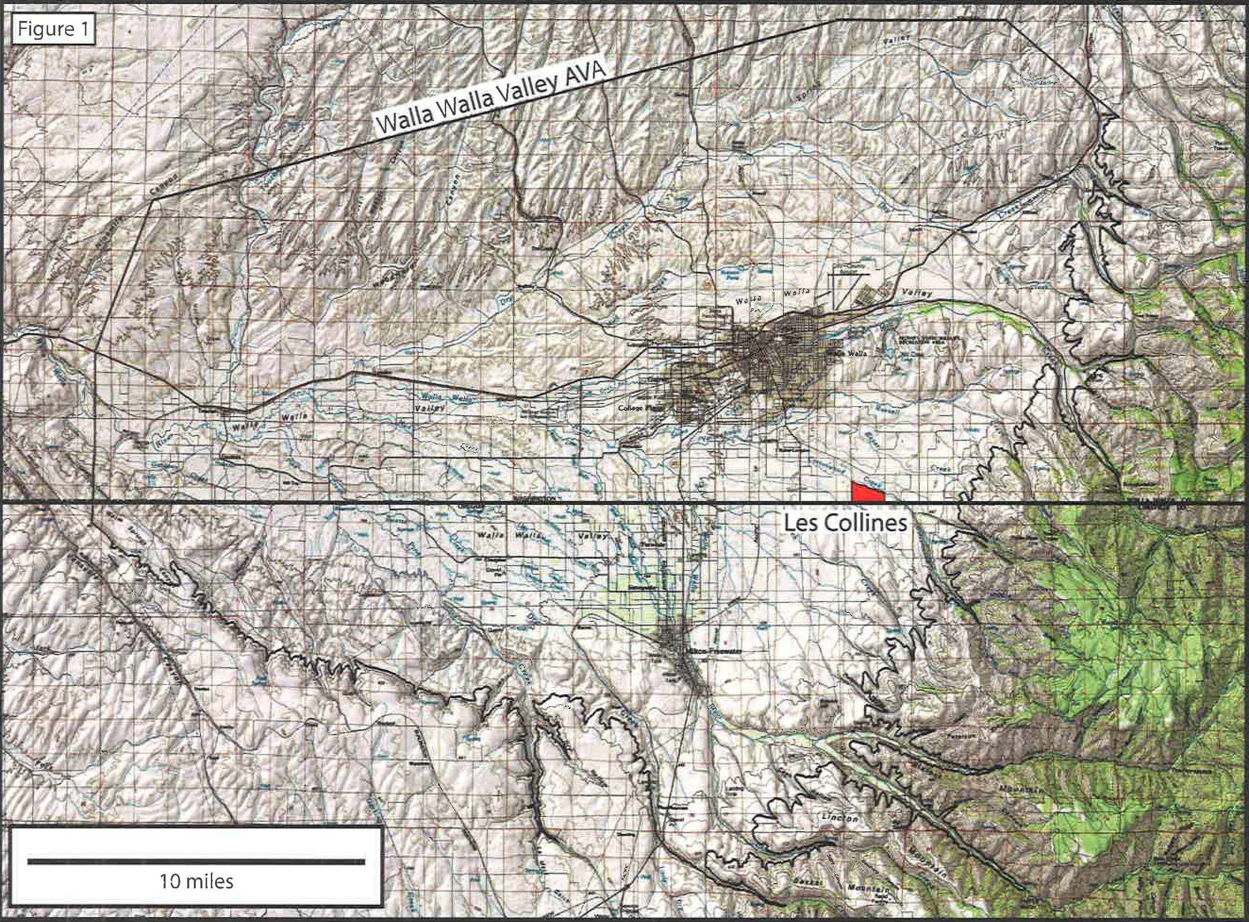
Les Collines Vineyard occupies approximately 290 acres in the foothills of the Blue Mountains, 5 miles southeast of Walla Walla, Washington (fig 1). The center of the vineyard is located near 46.004°N, 118.274°W. The southern boundary of the vineyard coincides with the border between Washington and Oregon. The vineyard lies within the Columbia Valley and Walla Walla Valley American Viticultural Areas (AVAs) and is situated on a broad, generally west-sloping ridge of low-relief bounded by the drainages of Cottonwood Creek on the north and a small unnamed ephemeral stream to the south (fig. 2). The slope of the vineyard increases gradually from 1.5° on the west to 6° on the east, as the Blue Mountains are approached. The elevation ranges from 1140 feet in the northwest corner of the vineyard to 1370 feet in the southeast corner.

Geology
The bedrock of the Blue Mountains and Walla Walla Valley consists of Columbia River Basalt, a dark-colored fine grained volcanic rock that was erupted from fissure systems in southeastern Washington and northeastern Oregon during the Miocene Epoch, around 15 million years ago. Basalt bedrock is not exposed at Les Collines, but crops out one mile southeast of the vineyard in the walls of the canyon of Cottonwood Creek.
Along the foothills of the Blue Mountains and in the adjacent Walla Walla Valley, basalt bedrock is overlain by a thick layer of weakly cemented basalt cobblestone gravels, derived from the erosion of the Blue Mountains, as they were rapidly uplifting around 5 million years ago. These gravels are informally known as the “old gravels” to distinguish them from the gravels that comprise the alluvial fans of the modern-day streams. The old gravels are often capped by a 4ft. thick section of carbonate-cemented sediment (caliche), the remnant of an ancient soil formed under arid to semiarid conditions.
During the Pleistocene Epoch, between 15 and 12 thousand years ago, the Walla Walla Valley was repeatedly inundated by catastrophic floods derived from the glacial dam failure in northern Idaho that drained Glacial Lake Missoula. The largest of these ice-age floods filled the valley to an elevation of 1200 ft., but the majority were significantly smaller, only inundating elevations below 1000 ft. At the lowest elevations of the Walla Walla Valley, in areas that were the most frequently flooded, flood-deposited sediment accumulated to thicknesses of over 100 ft. The thickness of flood-deposited sediment in the Walla Walla Valley gradually decreases with flood erosion. Approximately 40% of the area Les Collines lies within this >1100 ft. zone that was inundated by the largest floods, so remnants of flood sediment, including gravel, sand, and rocks transported within flood-borne icebergs would be expected to be present in this area.

Throughout most of the Columbia Basin and Blue Mountains, the surface material, in which soils are developed, consists primarily of wind-deposited silt and fine sand known as loess. The loess was derived by glacial erosion of granite-rich rocks that are exposed north and west of the Columbia Basin, so it is rich in quartz, unlike the basin’s ubiquitous basalt bedrock. The fine-grained glacial sediment was entrained in the ice-age flood events that swept the basin, and then deposited as the floods receded. The prevailing winds later swept the dried sediment from the floor of the basin and transported it to the north and east. By the time the glaciers retreated and ice-age flooding ceased, approximately 12,000 year ago, much of the landscape of eastern Washington had been buried by many feet of wind-deposited silt and sand. In the Blue Mountain foothills, thicknesses of loess typically range from 2 to 30 feet, depending on elevation, slope, and aspect. At Les Collines, loess thickness averages from 10-12 feet. Figure 3 illustrates the relationship between loess and underlying materials.
soils
The soils of Les Collines Vineyard are largely mollisols, soils of temperate grasslands, formed in wind-deposited sediment, known as loess, sourced from glacial outburst flood deposits. The mineralogy of the loess is dominated by quartz, feldspar, and mica that was derived by grlacial erosion from granitic rocks exposed north and east of the Columbia Basin. The soils consist largely of silt-sized grains, and average 70% silt, 20% fine sand, and 10% clay. In their pristine state, mollisols typically contain a surface layer enriched in organic matter by the decay of plant roots, known as a mollic epipedon. Tilling and erosion related to intensive farming can remove or dillute the mollic epipedon.
The USA NRCS has mapped and classified the soils of Les Collines into three soils series. The majority of the soils (255 acres) are classified as Walla Walla series, described as “deep and very deep, well drained soils formed in loess on hills.” Unfarmed Walla Walla soils typically have an organic-enriched mollic epipedon that is 12-18 inches thick. They also typically have an alkaline zone of disseminated pedogenic calcium carbonate at depths of four to six feet. The depth to bedrock or other substratum is typically greater than eight feet.


Two pits within the Walla Walla series soils revealed deep silt loam soils typical of the series, with disseminated calcium carbonate at a depth of 6 feet. Grapevine roots of 0.5 inch diameter were observed at depths up to eight feet in both pits. In one pit, a hand-drilled auger encountered caliche-encrusted basalt cobblestones at a depth of 12 feet, indicating that the “old gravels” form the substratum in that area.
Approximately 25 acres of the eastern, higher elevation parts of Les Collines feature soils classified as Athena series. Athena series soils are deep, well drained, and loess-based similar to soils of the Walla Walla series, but undisturbed profiles have a mollic epipedon that is thicker, darker, and more enriched in organic matter than that of Walla Walla series soils. Similar to the Walla Walla soils, Athena series soils contain an alkaline zone of pedogenic carbonate at depths of four to six feet.

climate
The Climate of Les Collines Vineyard is strongly influenced by its elevation, which is high relative to the floor of the Walla Walla Valley, and by its proximity to the Blue Mountains. The Walla Walla Valley narrows downstream toward its confluence with the Columbia River, causing cooler air draining westward from the Blue Mountains to pool on the valley floor. Because of the phenomenon, the coldest morning low temperatures in the Walla Walla Valley AVA are generally recorded at its lowest elevations. Lower elevations also have an enhanced probability of experiencing below-freezing temperatures on later dates in the spring and at earlier dates in the fall and are more likely to experience lower winter minimum low temperatures.
As is typical for most areas, afternoon high temperatures tend to decrease with elevation in the Walla Walla Valley. Since Les Collines is situated above the valley floor in the Blue Mountain foothills, it experiences afternoon high temperatures that are somewhat (usually 2-7° F) cooler than those at lower elevations. Since the increase in morning low temperatures at Les Collines relative to lower elevations is greater (often 10-15°) than the corresponding decrease in afternoon high temperatures, the net effect is to increase the values for both average temperature and growing degree-days. Using temperature data for three years (2007-warm, 2011-cool, 2012-normal) from Walla Walla Valley weather stations located at elevations between 1100 and 1600 feet, maximum values for average growing season temperature (Apr. 1-Oct. 31) were computed to reach a maximum between elevations of 1260 and 1340 feet. The computed maximum elevation for growing degree-day values ranged from 1310 to 1360 ft.

In 2012, which is considered a “classic” (average) year in the Columbia Basin with respect to viticultural climate conditions, Les Collines recorderd an average growing season temperature of 64.2°F and 3291 growing degree-days. This average growing season temperature is warmer than values typical for Bordeaux but cooler than Napa Valley. Figure 4 illustrates a graph of growing degree-days for 2012. Les Collines accumulates a greater percentage of its total GDD during September and October than most other vineyards in the Walla Walla Valley AVA because it generally has much warmer morning low temperatures due to its relatively high elevation.
When compared to the other vineyards throughout the Columbia Basin, Les Collines tends to have a longer than average growing season, warmer than average morning low temperatures, cooler than average maximum high temperatures, near average growing season average temperatures, and a greater number of growing degree days.
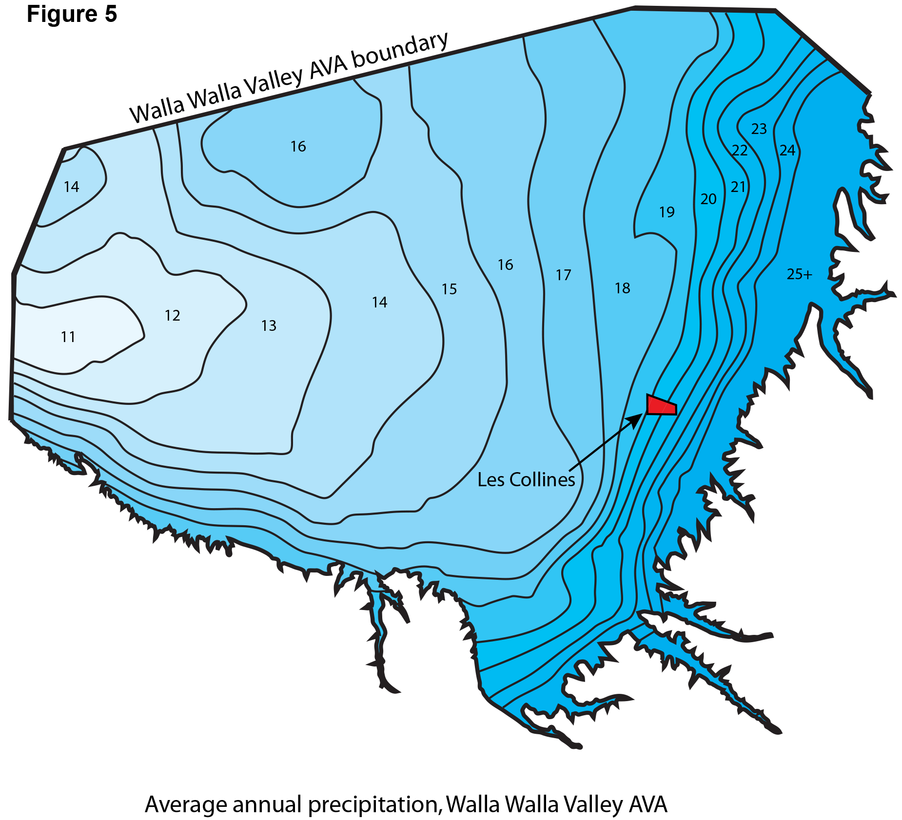
Due to the atmospheric phenomenon known as orographic lifting, whereby prevailing winds are forced aloft by mountains to promote cooling, condensation, and precipitation, Les Collines receives more precipitation than most other parts of the Walla Walla Valley AVA. Figure 5 shows that average annual precipitation rapidly increases from west to east across the AVA. Les Collines annually receives 19-21 inches of precipitation, on average.
implications for viticulture
Located on a gently-sloped hillside that promotes cold air drainage in three directions, Les Collines is well-situated for viticulture. Its elevated foothills location provides protection from late spring and early fall frosts and decreases the likelihood of damage related to Arctic air invasions during the late fall and winter.
Les Collines has generally homogeneous well-drained soils that provide no impediment to root penetration to depths of over 10 feet. The homogeneity of the soils lessens the challenges of managing viticulture both along and between rows of vineyard blocks. The silty soils allow water to infiltrate gradually and uniformly, encouraging vines to root deeply, as evidenced by roots exposed in pits at depths of over eight feet. Due to the depth and porosity of the soil, which creates a large water holding capacity, and average yearly precipitation of 20 inches, irrigation requirements for Les Collines are minimal, especially when compared to vineyards located in the desert (< 10 in. annual precipitation) climate of the central Columbia Basin. A 2014 MS thesis that evaluated the Walla Walla Valley AVA for dryland viticulture included part of Les Collines in its “suitable” zone.
Due to its relatively high elevation and topography, which results in warmer morning low temperatures, the growing season at Les Collines is one of the longest in the Columbia Basin and the growing degree-day values and growing season average temperatures are among the highest in the Walla Walla Valley. The relatively higher elevation of Les Collines results in lower afternoon high temperatures, which can have a positive affect when temperatures in valley floor locations exceed 100° F, as they commonly do in July and August. A comparison of temperature data recorded in Walla Walla Valley vineyards situated between 1100 and 1600 feet, showed that Les Collines is situated very near the “sweet spot” in the Walla Walla Valley AVA, where frost risk is minimized and average growing season temperatures and growing degree-days reach their maximum value before falling off with increasing elevation.

Pictured above: Night-lapse photo of springtime bud-break at Les Collines Vineyard